|
|||||||||||||||||||||||||||||||||||||||||||||||||||||||||||||||||||||||||||||||||||||||||||||||||||||||||||||||||||||||||||||||||||||||||
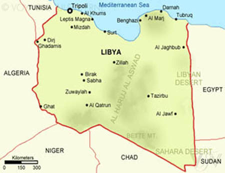
Libyan Location:-
Libya, the fourth largest state in Africa, is located in North Africa and lies between latitudes 33°N and approximately 20°N and longitudes 20°E and 25°E. It possesses a Mediterranean coastline of approximately 2000 Km in length. It is bordered by Egypt to the east, Sudan to the southeast, Chad and Niger to the south with Algeria and Tunisia to the west and northwest respectively.Libya has an area of approximately 1,775,500 sq.km, and a population of about 6,000,000 (1995), the capital city being Tripoli(OEA). Libya is a cultural and geographic bridge firstly between Egypt and the Arabian lands to the East, and the territory of the Arab W. Secondly, Libya acts as a link between the Mediterranean/Europe and sub-Saharian Africa.
MAP TOURS:-
Climate :-
Due to the lack of natural barriers, the climate is greatly influenced by the desert to the south and the Mediterranean Sea to the north. The coastal regions have a Mediterranean climate with moderate temperatures and enough rain during the winter season for grain farming. Annual precipitation averages 380 mm (15 in) and falls mainly in winter, and in the southern deserts, frequent periods of drought occur. A scorching wind called the "GHIBLI" which is a hot, very dry, occasionally blows into the usually humid coastal towns. The wind is most noticeable in Western Libya and is often associated with the spring solstice.
Copyright ©2005 AL RWASI For Travel & Tourism